
Suburb Profile - Wollert
A fantastic suburb in Melbourne’s North with great potential
Introduction
Located north of Epping, the name Wollert is an Aboriginal word meaning “where possums abound”.
From 1836 until the early 1850s, sheep raising was the main activity. In 1853, much of the land was subdivided into smaller farm lots, and necessary access roads laid out. During this period Wollert became a dairying community, with significant dairy production continuing for the Melbourne market until the 1960s. In more recent years, dairying has largely ceased and smaller-scale grazing and Wollert’s quarrying and brickmaking facilities represent the suburb’s main industries.
West of Wollert, at the junction of the Merri Creek and Summerhill Road, was another village called Kinlochewe. At its peak in 1848, about 400 people lived in its vicinity. However it was completely destroyed in the 1851 Black Thursday bushfires.
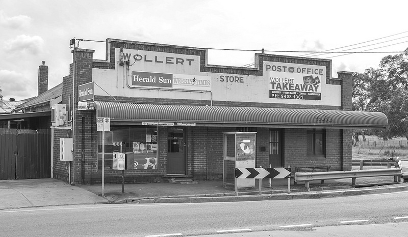
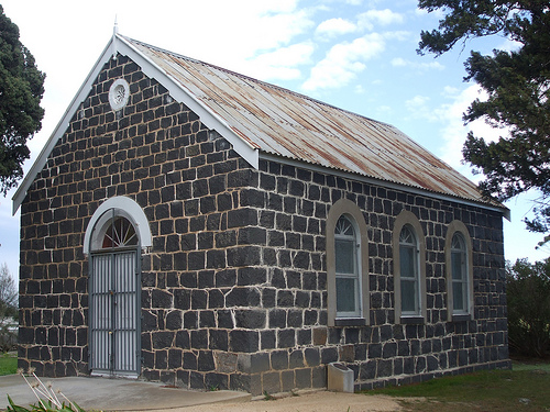
The first school, established by the Church of England, commenced in 1852. A bluestone Government school replaced it in 1877 and continued until 1994. A Methodist Church was built in 1878 to replace an earlier one built in 1859. This church continued as the Wollert Uniting Church. The Wollert General Store is still in operation, but the adjacent Dance Palais is no longer is use. Wollert Post Office opened on 1 September 1876, closed in 1895, then reopened in 1902.
During the late 1940s, several large Wollert properties were purchased by the Soldier Settlement Commission. They were then subdivided and allocated to eligible ex-servicemen.
The City of Whittlesea’s rural north includes the suburbs of Donnybrook, Eden Park, Humevale and Woodstock, the northern part of Wollert, the non-urban part of Whittlesea, the City of Whittlesea parts of Beveridge and Kinglake West, and most of the City of Whittlesea part of Yan Yean.
A village grew up along Epping Road, near Lehmanns Road, which included a couple of churches and a State School (1877-1994). Later, near the corner of Epping and Bridge Inn Roads, a post office (1876), a twentieth century ‘dance palais’, a sports reserve and a CFA station were established. Wollert’s unique drystone walls, as well as a number of mid to late 19th century homesteads, stand as a reminder of its past.
From 1836 until the early 1850s, sheep raising was the main activity. In 1853, much of the land was subdivided into smaller farm lots, and necessary access roads laid out. During this period Wollert became a dairying community, with significant dairy production continuing for the Melbourne market until the 1960s. In more recent years, dairying has largely ceased and smaller-scale grazing and Wollert’s quarrying and brickmaking facilities represent the suburb’s main industries.
West of Wollert, at the junction of the Merri Creek and Summerhill Road, was another village called Kinlochewe. At its peak in 1848, about 400 people lived in its vicinity. However it was completely destroyed in the 1851 Black Thursday bushfires.
The first school, established by the Church of England, commenced in 1852. A bluestone Government school replaced it in 1877 and continued until 1994. A Methodist Church was built in 1878 to replace an earlier one built in 1859. This church continued as the Wollert Uniting Church. The Wollert General Store is still in operation, but the adjacent Dance Palais is no longer is use. Wollert Post Office opened on 1 September 1876, closed in 1895, then reopened in 1902.
During the late 1940s, several large Wollert properties were purchased by the Soldier Settlement Commission. They were then subdivided and allocated to eligible ex-servicemen.
The City of Whittlesea’s rural north includes the suburbs of Donnybrook, Eden Park, Humevale and Woodstock, the northern part of Wollert, the non-urban part of Whittlesea, the City of Whittlesea parts of Beveridge and Kinglake West, and most of the City of Whittlesea part of Yan Yean.
A village grew up along Epping Road, near Lehmanns Road, which included a couple of churches and a State School (1877-1994). Later, near the corner of Epping and Bridge Inn Roads, a post office (1876), a twentieth century ‘dance palais’, a sports reserve and a CFA station were established. Wollert’s unique drystone walls, as well as a number of mid to late 19th century homesteads, stand as a reminder of its past.
Land use
The rural north includes the rural balance of the City of Whittlesea, including some rural-residential areas.
The non-urban areas are characterised by forest, cattle grazing, farming and poultry, horse and dog breeding.
Population
The 2011 population for the rural north was 3,317, with a population density of 0.10 persons per hectare.
The 2016 population forecast for the rural north is 3,248, and is forecast to grow to 3,808 by 2036.
The number of dwellings in the rural north is forecast to grow from 1,123 in 2011 to 1,276 in 2026, with the average household size falling from 2.96 to 2.92 by 2026.
Demographics
The rural north had a lower proportion of pre-schoolers and a higher proportion of persons at post retirement age than the City of Whittlesea in 2011.
There were 26 people over the age of 85 living in the rural north in 2011, with largest age group being 50 to 54 year olds.
Diversity
In the rural north, 15 per cent of people spoke a language other than English at home in 2011.
In 2011, 11 per cent of people in the rural north came from countries where English was not their first language.
The 3 largest ancestries in the rural north in 2011 were Australian, English and Italian.
Employment
1,718 people living in the rural north in 2011 were employed, of which 60 per cent worked full-time and 36 per cent part-time. More rural north residents worked in construction than any other industry in 2011. There were more technicians and trades workers in the rural north in 2011 than any other occupation.
In the rural north 17 per cent of the population reported doing some form of voluntary work in 2011, which is higher than the City of Whittlesea average of 9.7 per cent.
Families and households
In the rural north, 45 per cent of households were made up of couples with children in 2011.
In the rural north, 83 per cent of households were purchasing or fully owned their home, 11.2 per cent were renting privately, and 0 per cent were in social housing in 2011.
Car ownership
Analysis of car ownership in 2011, indicates 81 per cent of households in the rural north had access to 2 or more motor vehicles, compared to 61 per cent in the City of Whittlesea.
Future growth
In 2010 the State Government extended the Urban Growth Boundary to allow additional urban development to take place in Melbourne’s outer suburbs.
Precinct Structure Plans
Precinct Structure Plans are high-level master plans for whole communities. They lay out roads, retail hubs, schools, parks, housing, employment, connections to transport and generally address biodiversity, cultural heritage, infrastructure provision and funding through the development contributions plan.
The Metropolitan Planning Authority (MPA) is the statutory authority responsible for overseeing the preparation of all Precinct Structure Plans in Melbourne’s growth areas and advising the Minister for Planning on their approval.
The MPA is working in partnership with growth area councils, which includes the City of Whittlesea to complete the planning for Melbourne Growth Areas.
In the City of Whittlesea, the extension of the Urban Growth Boundary has created several future growth areas that will be planned and developed over the next 5 to 30 years.
The State Government’s, Metropolitan Planning Authority, in partnership with Council, has currently prepared the Wollert Precinct Structure Plan. You can view the plan HERE
Major surrounding features

• Yan Yean Reservoir Park
https://directory.whittlesea.vic.gov.au/parks/yan-yean-parks/yan-yean-reservoir-park.aspx Managed by Melbourne Water. The Reservoir supplies the northern and central suburbs of Melbourne.
• Toorourrong Reservoir Park (Whittlesea)
https://directory.whittlesea.vic.gov.au/parks/humevale-parks/toorourrong-reservoir-park.aspx
Managed by Parks Victoria. Completely destroyed during the 2009 bushfires, the Victorian Government spent $5.1 million rebuilding the park which re-opened to the public in late 2015 and is also home to the Whittlesea Bushfire Memorial.
• Kinglake National Park
Has 23,210 hectares of tall forests, fern gullies and rolling hills, an extensive network of walking tracks and other facilities, as well as vantage points offering scenic views. It protects almost 600 native plant species, over 40 native mammal and 90 native bird species.
• Growling Frog Golf Course (Yan Yean)
http://www.growlingfroggolfcourse.com.au/
The course has first class facilities including a restaurant and café, dedicated driving range, putting green, chipping green, practice bunker and more. The creation of a dedicated recycled water supply has ensured there will be plenty of water to keep the course maintained at the highest standard throughout the year.
• Whittlesea Golf Club
http://www.whittleseagolfclub.com.au/
Situated in the Humevale Valley, houses a challenging 18-hole layout for golfers of all standards.
• T H Hurrey Recreation Reserve (Yan Yean)
https://directory.whittlesea.vic.gov.au/parks/yan-yean-parks/t-h-hurrey-recreation-reserve.aspx
Facilities at this 4-hectare park include 4 tennis courts (asphalt), a pavilion and changerooms, barbecues, picnic facilities, and a public toilet.
• Tuttle Recreation Reserve (Wollert)
https://directory.whittlesea.vic.gov.au/parks/wollert-parks/tuttle-recreation-reserve.aspx
Facilities at this 2.16 hectare park include 2 public access tennis courts (synthetic grass), a pavilion and clubrooms, picnic facilities, barbecues and public toilets.
Sources:
https://en.wikipedia.org/wiki/Wollert,_Victoria
https://www.whittlesea.vic.gov.au/building-planning-development/future-development-plans/place-snapshots-a-guide-to-development-in-your-area/place-snapshot-wollert/
https://en.wikipedia.org/wiki/Wollert,_Victoria
https://www.whittlesea.vic.gov.au/building-planning-development/future-development-plans/place-snapshots-a-guide-to-development-in-your-area/place-snapshot-wollert/

Call
Say hello
Shops 2 and 6, 772-780 High Street, Epping VIC 3076
Copyright © 2023 Ristic Realestate. All Rights Reserved.
Site design & developed by Livelong Digital